
Aircraft Flight Routings
When aircraft depart and arrive at YVR, they follow published procedures and routings that are designed to ensure safe movement of aircraft. The flight patterns and the distribution of YVR aircraft over the Lower Mainland are highly dependent on which runway is active at the airport (i.e., the direction of take-offs and landings).
Active Runways at YVR
Active runways are determined by wind conditions on the airfield as aircraft must take off and land into the wind for safety reasons. At YVR, winds are typically from the east or west, the same orientation as the parallel runways.
When winds are from the west, take-offs occur over the Strait of Georgia and landings over the city (Runway 26 operations). When winds are from the east, take-offs occur over the city and landings over the Strait of Georgia (Runway 08 operations).
The wind conditions at the airport have strong seasonal characteristics. Based on historical observations, YVR typically sees more easterly wind conditions during fall and winter and more westerly wind conditions during spring and summer. However, being close to the water, winds often shift during the course of the day, resulting in runway directions to change.
Minimizing Noise Impacts - Preferential Runway Use
To mitigate noise on the nearby communities, YVR operates using the Runway 26 configuration whenever wind conditions permit. This places take-offs, the noisiest aircraft operations, over the water and away from populated areas.
Flight Paths and Procedures
Flight paths and procedures are designed to meet national and international standards to ensure a high level of safety and safe separation between aircraft. The flight path taken by an aircraft depends on active runways at the airport, origin and destination airports, aircraft performance, traffic level, and the instructions provided by air traffic control. Figures 1 and 2 illustrate general flight patterns observed during Runway 26 and Runway 08 operations over a six-hour period.
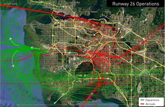
Figure 1: General Flight Patterns During Runway 26 Operations
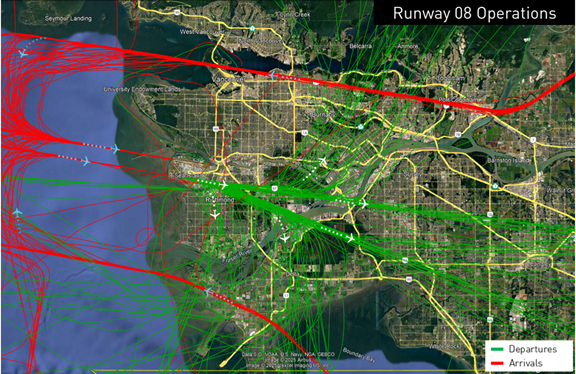
Figure 2: General Flight Patterns During Runway 08 Operations
The airspace over the Lower Mainland is very confined and one of the most complex in Canada. This is due to several factors including the mountains to the north, U.S. airspace to the south, numerous airports in the region (e.g., Boundary Bay Airport, Langley, Pitt Meadows, Vancouver Harbour), and the diverse mix of aircraft operating in the same airspace. As a result, arrival and departure procedures are highly structured, and all parts of Metro Vancouver experience some level of aircraft over-flights.
New Arrival Procedures - Vancouver Airspace Modernization Project
On November 27, 2025, NAV CANADA implemented new arrival routes and procedures at YVR as part of the Vancouver Airspace Modernization Project (VAMP) to enhance safety and modernize the airspace. As a result, some areas in the Lower Mainland may be observing changes to air traffic patterns associated with YVR arrival aircraft. There were no changes to the routes and procedures used by departing aircraft and aircraft operating under Visual Flight Rules (VFR).
To learn more about VAMP and the changes introduced, please visit www.navcanada.ca/vamp.
Do you have additional questions?
Please contact the YVR Noise Management office.
You can also view “real-time” and historical flight tracks over your neighbourhood using the YVR WebTrak system.